Via Radio Iowa with local information from the KROS NEWSROOM
As many as three tornadoes touched down in eastern Iowa during last night’s severe thunderstorms. One of those was in Clinton County.
Survey teams are being dispatched this morning to look over the damage and talk with first responders and other witnesses. Meteorologist Tim Gross, with the National Weather Service in Davenport, says there were three tornado warnings issued during the storm.
“There was a tornado warning southwest of Williamsburg in Iowa County and there was another one for the Iowa City metro about 6:15,” Gross says. “There was another one for De Witt in Clinton County.” The strongest wind gusts reported during the storm reached 83 miles an hour at the Iowa City Municipal Airport. No injuries are reported from the severe weather, as yet, but there’s widespread damage to trees and utility poles.
Clinton County Emergency Management Agency Director Chance Kness says the National Weather Service has informed him there was a ‘weak EF0 tornado’ south of Grand Mound. He says the NWS is still looking into the damages and there could be other reports. Kness says there was county-wide straight line wind damage. The EMA Director says there were reports of limbs and trees down and power outages plus some flash flooding reported across the county. In addition the Calamus-Wheatland School Building sustained damage in the storm and had to cancels school today. Eagle Point Park in Clinton was temporally closed this morning while crews cleaned up tree damage at the park.
Clinton Area Official Weather Observer Jim Blaess reports 2.7 inches of rain in the storms. He said some came in the afternoon and then again from 7:30 in the evening and overnight. He says the rainfall total from August 15th to today (Wednesday) is 6.75 inches and the month’s total is 7.38 inches.
The National Weather Service reports a 59 mile an wind gust recorded in DeWitt and a 61 mile an hour gust in Clinton. Both of those were recorded about 7:40.
“On the southeast portions of Iowa City, there was 60 to 80-mile-an-hour winds,” Gross says. “As a result, there were a lot of downed power lines and trees and power outages in Iowa City and the Quad Cities. The Quad Cities had more like 50 to 60-mile an hour winds.” As many as 5,000 homes and businesses lost power in Iowa City during the height of the storm, while another two- to-three-thousand homes were dark in the Quad Cities area.
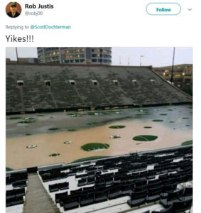
Kinnick Stadium was struck by flash flooding, causing giant bubbles of artificial turf to rise up in the brown water, though University of Iowa officials say the football field will be ready for Saturday’s season opener.
|
|
The far southeastern corner of Iowa also got drenched. “We had one storm spotter call us with 5.1 inches of rain in extreme northwest Des Moines County,” Gross says. “Lee County, the Keokuk area, had a lot of tree damage as well and the Keokuk Lock and Dam on the Mississippi River reported 4.9 inches of rainfall.” A rainfall record was set in the Quad Cities on Tuesday with 3.31 inches, breaking the previous longtime record of 2.7 inches that was set in 1872.