


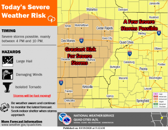
Scattered thunderstorms are expected across the region this afternoon and evening. There is an enhanced risk for severe weather from around the Interstate 380 corridor near Cedar Rapids and Iowa City and points southwest. The remainder of the area has a low threat for severe weather. The main hazards are large hail, strong winds, and isolated tornadoes. Storms are expected to be fast moving. Please be weather aware and continue to monitor later forecasts for updates.
Link (pdf): NWS Story on severe weather forecasts


