


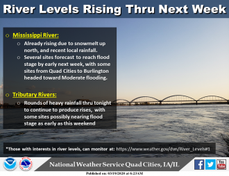
Rises on area rivers are expected to continue this weekend and into next week from a combination of locally heavy rainfall and snow melt from up north. Several sites on the Mississippi are forecast to rise to the flood stage by early next week. Some sites from the Quad Cities on south to Burlington may even hit moderate flood levels next week. Some area tributary rivers will also rise to near the flood stage this weekend, especially with the Iowa, Cedar, Wapsi, Pecatonica and Rock rivers being most at risk. Monitor river levels at: https://www.weather.gov/dvn/River_Levels#1
914 PM CDT Wed Mar 18 2020
The Flood Watch continues for
The Wapsipinicon River near De Witt 4S
* Until further notice.
* At 8:30 PM Wednesday the stage was 9.9 feet.
* Flood stage is 11.0 feet.
* Minor flooding is possible.
* Forecast, Rise above flood stage Friday…and continue rising to 11.4 feet Saturday morning.
* This forecast is based on routed flow from upstream in combination with forecast rainfall. Consequently there is limited confidence in the river reaching flood stage.
==
859 PM CDT Wed Mar 18 2020 The National Weather Service in Quad Cities has issued a* Flood Watch for The Mississippi River at Camanche* Until further notice.*
At 8:30 PM Wednesday the stage was 14.4 feet.*
Flood stage is 17.0 feet.* Minor flooding is possible.*
Forecast, Rise above flood stage Tuesday morning…and continue rising to 17.5 feet Wednesday.*
This forecast is based on routed flow from upstream in combination with forecast rainfall. Consequently there is limited confidence in the river reaching flood stage.


