Hazardous Weather Outlook
This Hazardous Weather Outlook is for portions of north central
Illinois…northwest Illinois…west central Illinois…east
central Iowa…northeast Iowa…southeast Iowa and northeast
Missouri.
.DAY ONE…TODAY AND TONIGHT
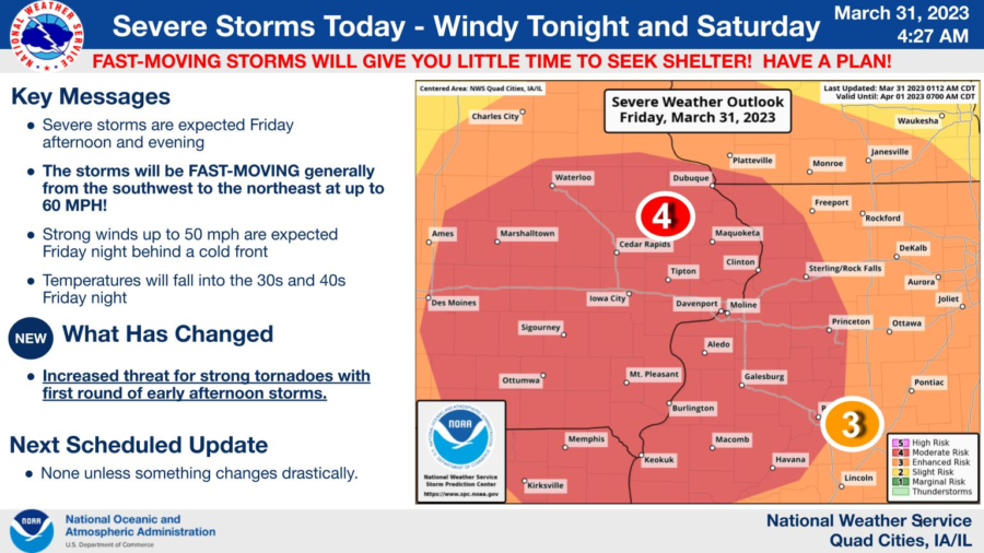
The Storm Prediction Center has a Moderate Risk, or level 4 out
of 5, for severe thunderstorms this afternoon and evening. The
main hazards will be damaging straight line winds of 75 mph,
tornadoes, and large hail. Some of the tornadoes could be strong.
The thunderstorms will be very fast moving, from southwest to
northeast at 60 mph.
Before the storms arrive, a very high grassland fire danger is
forecast due to the warm temperatures and strong winds. Any fires
that occur may be difficult to control and burning should be
avoided today.
Strong gradient southwest winds are expected this afternoon and
tonight with gusts up to 50 mph. A wind advisory is in effect.
.DAYS TWO THROUGH SEVEN…SATURDAY THROUGH THURSDAY
Strong northwest winds gusting up to 50 mph will continue through
much of Saturday morning.
.SPOTTER INFORMATION STATEMENT…
Spotter activation will likely be needed this afternoon and evening.