Link: NWS Friday Into Saturday View Link: NWS Weekend view
Buchanan-Delaware-Dubuque-Benton-Linn-Jones-Jackson-Iowa-Johnson-Cedar-Clinton-Muscatine-Scott-Keokuk-Washington-Louisa-Jefferson-Henry IA-Des Moines-Van Buren-Lee-Jo Daviess-Stephenson-Carroll-Whiteside-Rock Island-Henry IL-Bureau-Putnam-Mercer-Henderson-Warren-Hancock-McDonough-Scotland-Clark-
316 AM CST Fri Jan 14 2022
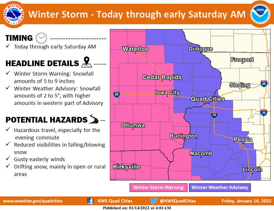
This Hazardous Weather Outlook is for portions of north central Illinois…northwest Illinois…west central Illinois…east central Iowa…northeast Iowa…southeast Iowa and northeast Missouri.
TODAY AND TONIGHT
A winter storm will impact the Midwest today through early Saturday morning. Snow will spread into eastern Iowa this morning, and over Illinois and Missouri this afternoon. Roads will become slick and snow covered quickly, and the evening commute is expected to be have snow covered roads and poor visibility.
A winter storm warning is in effect for locations west of line from Independence, through Cedar Rapids, Iowa City, through Burlington and Carthage Illinois. A winter weather advisory is in effect for much of the rest of the area through early Saturday.
Snow totals of 4 to 8 inches will be common over portions of eastern Iowa, northeast Missouri, and far west central Illinois, while totals of 3 to 5 inches are more likely closer to Dubuque through the Quad Cities. Lighter amounts, generally under 2 inches are forecast for northern Illinois. Some blowing and drifting snow is expected this evening and overnight.
Use extreme caution if traveling today and tonight, and delay travel if possible.